
Modernizing Statewide Parcel Management with UCPI and the OPN HUB
State and county governments need a unified, error-corrected, continuously updated parcel map capable of supporting modern land management, taxation, emergency response, permitting workflows, and AI-driven analytics.
The UCPI + OPN HUB framework delivers exactly that — with zero installation, no maintenance burden, and complete interoperability across all participating jurisdictions.
The OPN Structure
The Open Parcel Number (OPN) is a universal, machine-readable identifier assigned to:
- Parcel map boundaries
- Point-in-parcel (PIP) locations
- Legacy parcel records
- Update transactions
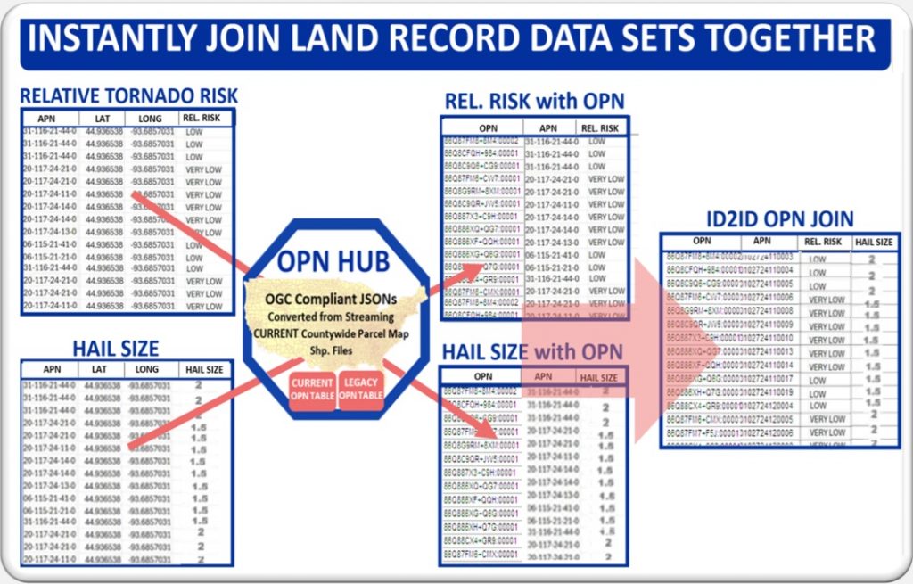
OPNs provide the foundational key that links datasets which were previously incompatible or siloed, enabling instant joining of records across counties, agencies, and systems.
Core Capabilities
Real-Time Statewide Parcel Map Updating
Every county or local parcel map sponsor automatically updates the OPN HUB whenever they save their local changes.
Once the UCPI API is integrated into the county’s SAVE script, all future changes sync automatically — ensuring the statewide parcel map is always current.
Data Sponsor ↔ OPN HUB Interface
Counties continue using their existing GIS platforms.
A lightweight interface securely transmits local parcel map changes and retrieves updated OPN assignments without requiring any new infrastructure.
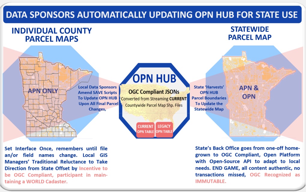
County / State Update API
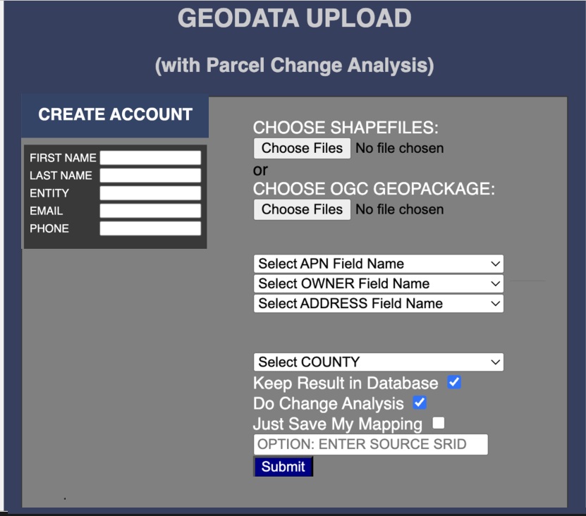
A simple, secure API allows counties to:
- Push new parcels
- Push edits and corrections
- Receive new OPN assignments
- Sync all changes with the statewide HUB
This ensures the entire state parcel map stays continuously up to date.
Key Benefits
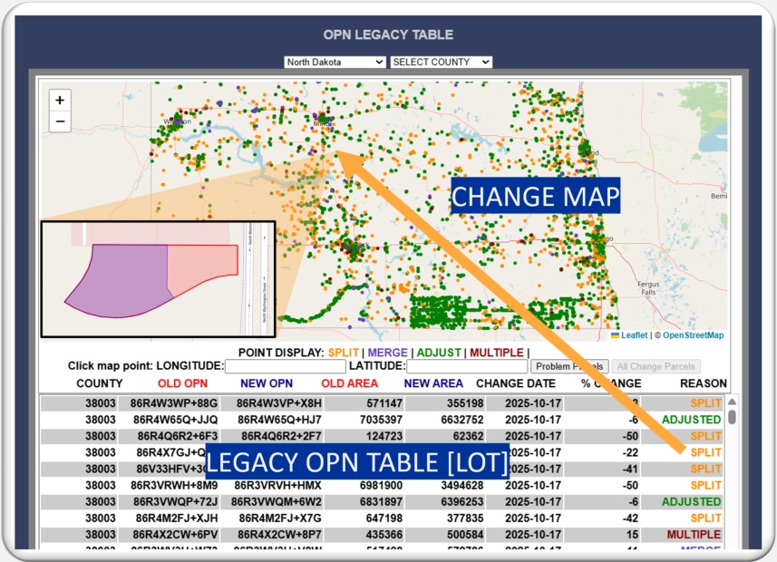
Change Map Tracking
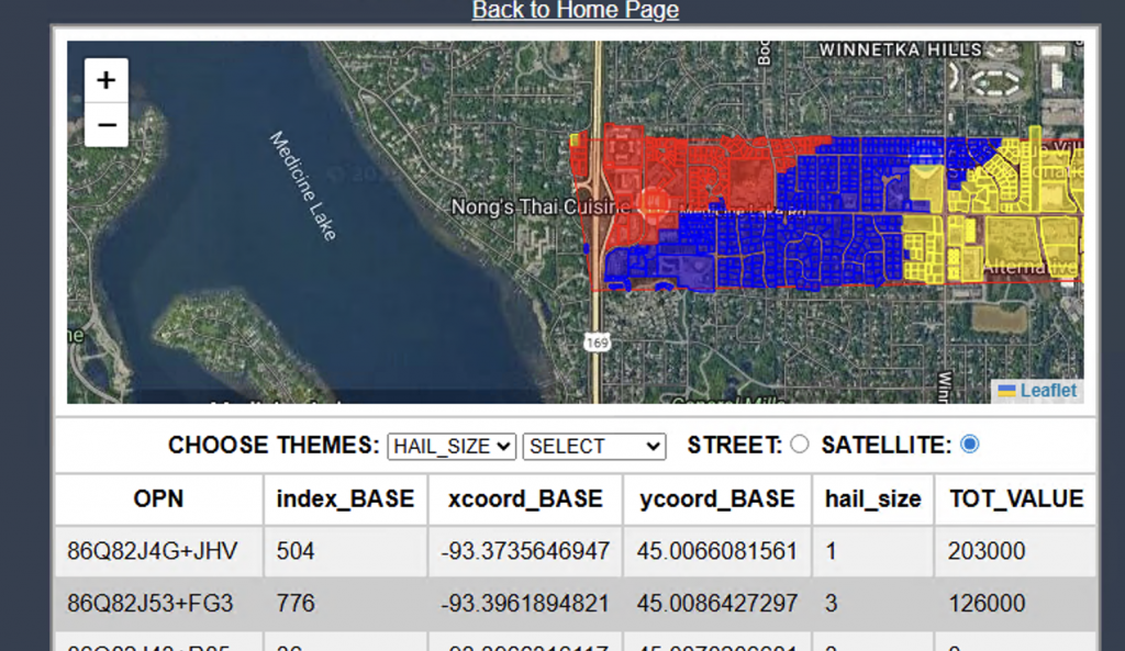
A navigable statewide Change Map provides a visual record of every parcel event — essential for auditing, taxation, permitting, dispute resolution, and AI-driven land analysis.
It captures:
- Lot splits
- Lot joins
- Boundary adjustments
- Drafting errors
- Owner changes
- Change dates
Irregular Mapping Detection
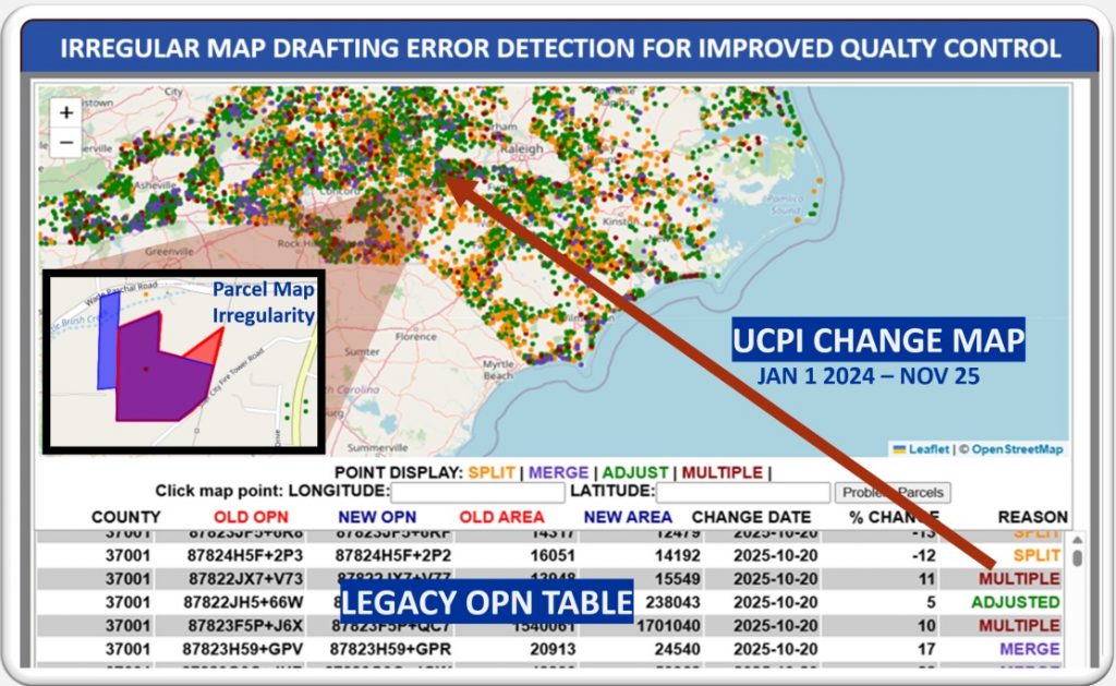
Automatically identifies:
- Overlapping polygons
- Boundary distortions
- Misalignments
- Drafting inconsistencies
This dramatically improves data quality and reduces manual correction time.
Legacy OPN Table
A complete historical record of all parcel events is preserved, including:
- Splits and joins
- Adjustments and corrections
- Ownership changes
- Time-stamped history of every update
This becomes the authoritative archive for land governance and analysis.
Interoperability
UCPI eliminates cross-agency silos by providing a neutral, Universal Common Parcel Indexing system.
Utilities, assessors, tax offices, emergency services, planning departments, and state agencies can finally interact using the same “parcel language.”
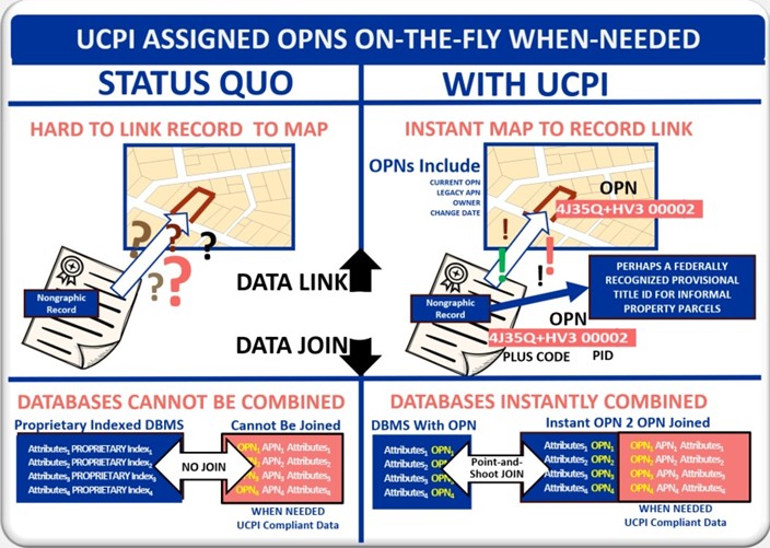
Data Silo Elimination
Any two tables — even with no shared parcel index — can be instantly joined using OPN assignments.
Examples include:
- Permits
- Sales
- Zoning
- Utilities
- Valuations
- Liens
- Claims
- Environmental records
OPN enables comprehensive, integrated analytics.
What Counties and States Gain by Saying YES
Automatic Updates
Counties use the UCPI API to update the OPN HUB every time GIS edits are saved — no new workflows, no new software.
Financial Incentives
The upcoming OPN Consortium will provide funding incentives for states and counties that adopt UCPI.
Free Change Map + Legacy OPN Table
States receive, at no cost:
- A unified statewide Change Map
- A Legacy OPN Table containing all splits, joins, and adjustments from the past year
Universal Table Joining API
Counties and states can merge datasets — even without common indices — enabling true interoperability and eliminating data silos.
No Installation, No Maintenance
Local GIS staff simply continue their normal workflows.
The OPN HUB automatically receives updates after every SAVE.
Automatic Statewide Map Update
The free UCPI API enables the state to automatically generate a continuously updated statewide parcel map from OPN HUB content.
The Immediate Ask
OPN USA is seeking a small number of states to participate as early partners in shaping the national UCPI framework and desired applications.
Participation includes:
- Providing UCPI’s Local/State Interface to all county parcel map sponsors
- Completing a one-time API activation form
- Integrating the UCPI API into local SAVE routines (with OPN USA support)
- Using the API to keep the statewide parcel map continuously updated
- Collaborating on optimizing interface functionality for both state and county data sponsors
Early participants ensure that their state’s priorities and requirements directly influence the national UCPI standard.